Local businesses, city council and residents were encouraged to turn off their lights in Leiden (the Netherlands) between 22:00 and 23:30 on the 25th of September in order to reconnect with the night sky and once again see constellations such as Cassiopea and stars such as Vega with the naked eye in the city famed for the oldest still existing University Observatory in the world. The initiative – called ‘Seeing Stars Leiden‘ – was conceived by artist Daan Roosegaarde, and UNESCO, and organised by the City of Leiden, Leiden University and other partners as part of the ongoing European City of Science Leiden2022.
During the event, residents and visitors to the city took light pollution measurements intending to compare the light on a naturally dark sky and an artificial light sky and be aware of the city’s light pollution. ‘Loss of the night’ and ‘Dark Sky Meter‘, two citizen science apps for Android and Apple systems, respectively, and developed by DDQ, were the chosen apps to collect light measurements.
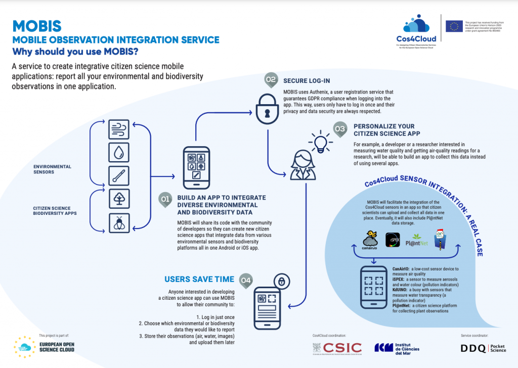
These two apps were connected to MOBIS back-end, a service to create integrative citizen science apps developed in the Cos4Cloud framework. “We connected the apps to MOBIS to process the light measurements data and showcase it with a map service in real time”, clarifies Norbert Schmidt, DDQ CEO and MOBIS developer in Cos4Cloud.
More than 150 people participated in the event by reporting more than 400 light measurements. All the data is opened and it is reflected on this map.
Testing MOBIS
The event was also an opportunity to test some functionalities of MOBIS: storing and processing data from different sources and systems, such as iOS and Android, and displaying the collected data on MOBIS map service in a standardised way. “We are pleased with the results, as everything worked well”, states Norbert Schmidt, DDQ founder and owner and MOBIS developer at the Cos4Cloud project.
MOBIS currently integrates the following apps and sensors Loss of the night, ‘Dark Sky Meter’, CanAir.io, Mini Secchi and soon iSPEX 2 as a back-end service. In particular, MOBIS meets all the requirements mobile citizen science apps and sensors have, among other things, support to collect offline observations; it has a powerful real time processing of large amounts of data (spectral images and night sky images); quick feedback for users thanks to the EGI high performance environment the MOBIS server is hosted; interoperable standards (Sensor Things API, JSON/REST APIs); python (flask) integration for data reduction services; push notification services for campaigns to notify citizens, a very user-friendly dashboard; libraries for native and hybrid development and “all the data is opened!”, adds Norbert Schmidt.
Recently, DDQ teamed up with the NEANIAS project to connect their citizen science atmospheric services to MOBIS.
“This is a huge opportunity to create citizen science campaigns which combine the weather service created by NEANIAS with air quality measurements using iSPEX 2 and our light pollution apps. It is also a nice example of how two EOSC H2020 projects can collaborate and find synergies.”
Norbert Schmidt.
- Are you interested in using MOBIS? You can find it in the EOSC Marketplace.
- Read more about ‘Seeing Stars Leiden’ in this post.